This site uses cookies to improve your experience. To help us insure we adhere to various privacy regulations, please select your country/region of residence. If you do not select a country, we will assume you are from the United States. Select your Cookie Settings or view our Privacy Policy and Terms of Use.
Cookie Settings
Cookies and similar technologies are used on this website for proper function of the website, for tracking performance analytics and for marketing purposes. We and some of our third-party providers may use cookie data for various purposes. Please review the cookie settings below and choose your preference.
Used for the proper function of the website
Used for monitoring website traffic and interactions
Cookie Settings
Cookies and similar technologies are used on this website for proper function of the website, for tracking performance analytics and for marketing purposes. We and some of our third-party providers may use cookie data for various purposes. Please review the cookie settings below and choose your preference.
Strictly Necessary: Used for the proper function of the website
Performance/Analytics: Used for monitoring website traffic and interactions
In modern surveying, navigation, and geolocation, understanding the difference between triangulation and trilateration is key. Triangulation pinpoints locations using angle measurements from known points, while trilateration, the backbone of GPS and indoor positioning systems, relies on distance measurements from multiple reference points.By
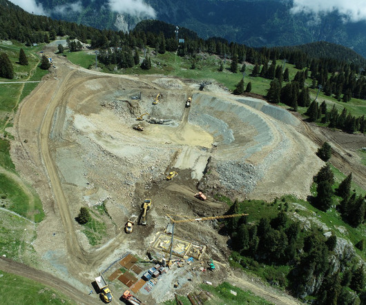
Surveying is the starting point for any construction project. Before we plan and construct any structure like buildings, dams, roads, rails, bridges, canals, or water works on land, we need to conduct surveys to collect the details of the land (field notes).So,
A report that surveyed more than 200 contractors in New York also highlighted workforce development programs, flexible work options and mental health resources.
The survey also flagged up growing concern about construction white collar skills shortages, paricularly building control surveyors and quantity surveyors. Chief economist Simon Rubinsohn warned: “The need to ensure the building safety regime works more smoothly is highlighted widely in the survey as a factor impacting development.”
Detailed design work is already underway along with planning condition sign-offs, site surveys and early setup activity. A landmark mixed-use building paves the way for over 400 build to rent homes overlooking Manor Square The project is expected to create more than 9,000 construction jobs.
The report comes as Construction products manufacturing returned to growth in the second quarter of 2025, according to the Construction Products Association’s latest State of Trade Survey.
Conducting Effective Site Surveys: Tools, Techniques, and Best Practices Discover the essential steps, tools, and techniques for conducting effective site surveys. The post Conducting Effective Site Surveys: Tools, Techniques, and Best Practices appeared first on ConstructionPlacements.
Sisk has already completed early surveys, design and vegetation clearance and will now move on to a two-year main works programme to prepare the land for the first 633 homes. Vast former gas works site at Hind Street will be transformed A funding package – made up of £29.8m from Homes England and £22.4m
TCC is providing commercial and quantity surveying services to construction managers, Tamworth-based WB Property Group and employers agent services to Birmingham-based Beauford Group – a specialist in student accommodation projects.
Joe Hayes, Principal Economist at S&P Global Market Intelligence, said: “Having trended upwards in recent months, our survey data for July signal a fresh setback for the UK construction sector, with total industry activity falling at the sharpest rate since May 2020. Work fell across all sectors with residential the hardest hit.
Contractors believe more can be done to protect workers and motorists alike, with 47% of respondents to an AGC survey saying jobsites are a greater risk now than a year ago.
For this 30,000-square-foot facility, Latitude 33 provided surveys, site design, grading plans, public improvement plans, storm water quality management plan, construction support & staking, and project coordination. The firm recently partnered with STK Architecture and Cox Construction Co.
Some 28 per cent thought it was actively bad for the sector, with issues like higher National Insurance rates potentially… The post Construction industry has mixed view on Budget measures, survey reveals appeared first on Construction News.
Headquartered in Bennett’s Hill, TCC is a multi-disciplined consultancy providing specialist project management, quantity-surveying, employers agent, building surveying and health and safety services to a wide range of sectors.
An engagement survey helps you understand your teams needs and how they feel about their work. Here are several reasons to use an employee engagement survey for your construction workforce. Spot Problems Early Engagement surveys help identify issues before they grow into bigger problems.
The increased provision comes after a fresh wave of intrusive surveys uncovered widespread issues with cavity barriers hidden behind brickwork and render. Taylor Wimpey has taken a massive £222m hit to cover legacy fire safety defects plunging the house builder into a first-half pre-tax loss of £92m.
Survey found that 82% of respondents expect an AI-driven transformation, but just 20% claimed their firm's readiness was at a mature or advanced level.
months in June, according to a member survey, the association announced. “In Notably, this survey predates the most recent trade policy announcements, and 1 in 5 contractors had a project interrupted or paused due to tariffs in June," he said.
A survey by Unite the union found that 31 per cent of women working in construction had been sexually assaulted at work, with… The post Survey reveals ‘shocking’ culture of sexual harassment in construction appeared first on Construction News.
The scope also includes façade and roof refurbishments, balcony works, ventilation upgrades, M&E compliance, and intrusive surveys. Up to 25 contractors will be appointed to carry out cladding removal, fire compartmentation, fire door installs, suppression systems, and structural repairs.
The new Leica DS4000 utility detection system combines advanced performance with intuitive usability, enabling construction, utilities, and surveying professionals to see more and reach deeper. Heerbrugg, Switzerland – Leica Geosystems, part of Hexagon, today announced the launch of the Leica DS4000.
Chartered building surveyor Mike McGill, with over 35 years’ experience in surveying, upgrading and adaptation of UK buildings, will head up the new service. This strategic expansion has led to G&H successfully securing a contract with UK property investment and development company, CEG.
AI Copilots for Quantity Surveyors: Estimating at Lightning Speed Discover how AI copilots and digital QS assistants are revolutionising quantity surveying—with features like automated takeoff, predictive forecasting, and seamless BIM integration.
Land surveys are an essential component of this phase. These surveys provide precise data on property lines, topography, and existing structures. With a reliable survey, developers can proceed with confidence, knowing they have a clear picture of the sites potential and limitations.
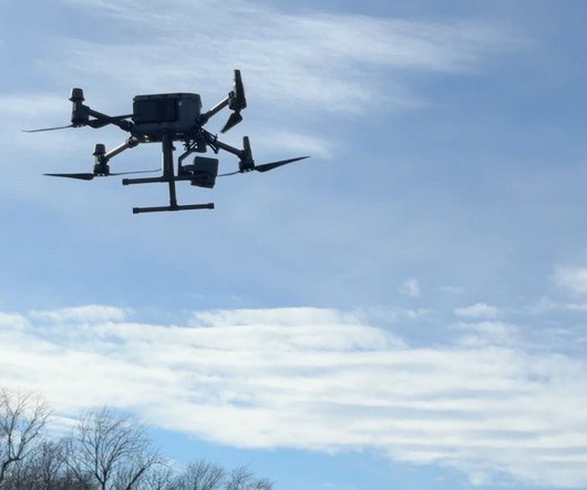
Drones and robotics will play a defining role in major construction projects, making surveying faster, safer, and more accurate. I previously found that a huge portion of my time was spent on surveying which I can now delegate to site managers. million additional workers needed to fill construction jobs in Europe by 2030*.
“Our divisions provide specialist assets (examples being highly technical survey and scanning equipment, press fit tools and access equipment) to niche end markets with a particular focus on site redevelopments, commercial fit outs and ‘clean rooms’ in data centres, food and beverage and pharma.
But he spent the summer in a very different role, field surveying. He reached out to a family friend, Doug Flath, a field survey manager with The Korte Company. When I started, I didnt know what surveying was all about, he said. Although field surveying wasnt Clints first internship choice, he has embraced the role.
In a recent Workforce Survey Analysis by the Associated General Contractors of America (AGC), 94% of respondents reported having openings for skilled labor positions in the construction industry, a 9% increase from 2023. Further, the AGC survey noted that 42% of respondents increased spending on training and development.
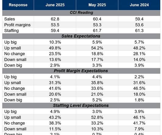
months in June due to a strong flow of data center projects, according to an Associated Builders and Contractors survey conducted June 20 to July 7. Notably, this survey predates the most recent trade policy announcements,” said Basu. Only expectations around staffing dipped in the most recent survey, according to ABC.
Drones conduct site surveys in minutes, capturing data that used to require days of manual measurement. Bricklaying robots can lay thousands of bricks per day with precision, while automated rebar-tying machines reduce repetitive strain injuries for workers. These innovations don’t replace human workers; they augment them.
The consultancy said that 97 per cent of the contractors surveyed for its latest UK Construction Market Report had declined tenders in the second quarter of 2025 – an increase from the… The post Contractors turning down tenders amid risk concerns appeared first on Construction News.
With a single flight, we can create 3D models, conduct thermal scans, perform quantitative takeoffs, and carry out surveys. He visits projects to capture progress through 4K video, still imagery, 2D site survey, 3D models, and periodic thermal scans. Drones enable us to cover larger areas more quickly and gather high-quality data.
Drones can survey sites faster and more accurately than traditional methods. Technology in Value Engineering Combining construction tech and value engineering is opening up new ways to save costs. For example: BIM software for construction management lets you simulate and compare different design options to find the cheapest solution.
Crews have cited enhanced responsiveness, air quality improvements and a significant reduction in noise, benefiting the operators, work crews and local community.
The report includes findings from a survey of over 200 general contractors, construction managers, and design-builders. It is a SmartMarket Brief that examines the current state of digital project management for general contractors in the US construction industry.
A survey by the Plumbing and Heating Federation has revealed that 69 per cent of businesses north of the border are experiencing low availability of… The post Scottish plumbing sector at ‘breaking point’ amid skills crisis appeared first on Construction News.
Top Lists Top Design Firms Revenue Increases at New York and New England Design Firms Click Here to Complete ENR New Yorks Top Design Firms Survey --> Top Contractors COVID Lessons Ready Northeast Firms For Potential Downturn Click Here to Complete ENR New Yorks Top Contractors Survey > Top Specialty Contractors Northeast Specialty Contractors Report (..)
A 2023 survey from Specsavers Corporate Eyecare reveals that nearly a quarter of tradespeople have experienced accidents on the job, yet over a quarter do not use protective eyewear consistently. This will allow construction workers to be 10 times closer to the arc than if they weren’t wearing them.
Survey Note: Detailed Analysis of Navigating the UKs 2025 Building Regs for Contractors Introduction: The Evolution of UK Building Regulations The UKs building regulations are set for a major update in 2025 with the introduction of the Future Homes Standard.
The firm is ranked 35th in Engineering News-Records Top 500 Design Firms survey and is 11th in its transportation category. Headquartered in New York City, the company has more than 60 offices and 3,200 employees who reimagine the solutions and structures that connect our communities.
Include a link to the recorded session, any additional resources mentioned during the webinar, and a survey to gather feedback on the event. Follow Up After the Webinar Once the webinar concludes, the engagement should not end. Send a follow-up email thanking attendees for their participation.
Top Lists Top Design Firms Revenue Increases at New York and New England Design Firms Click Here to Complete ENR New Yorks Top Design Firms Survey --> Top Contractors COVID Lessons Ready Northeast Firms For Potential Downturn Click Here to Complete ENR New Yorks Top Contractors Survey > Top Specialty Contractors Northeast Specialty Contractors Report (..)
According to Deloitte’s 2022 Global IFRS Lease Accounting Survey, 79% of companies said that IFRS 16 significantly affected their financial KPIs, including debt-to-equity ratios and EBITDA margins. That forced leadership to communicate clearly with stakeholders and lenders about the nature of these new “liabilities.”
We organize all of the trending information in your field so you don't have to. Join 79,000+ users and stay up to date on the latest articles your peers are reading.
You know about us, now we want to get to know you!
Let's personalize your content
Let's get even more personalized
We recognize your account from another site in our network, please click 'Send Email' below to continue with verifying your account and setting a password.


Let's personalize your content